1. WANTED ANY AIRSTRIP
OR FROM OREGON TO ARIZONA WITH MY FAMILY.
“Know thyself” was a dictum of the ancients, and I offer the suggestion that nothing like 10 days in the air with the family provides a faster shake-down flight. In those 10 days I managed to become temporarily lost over the desert at night, landed on an X-d off airstrip, and made a proud perfect landing on a restricted military field.
Reflecting on this trip, I’ve come up with three conclusions:
America’s western Seaboard is one of marked contrasts; the hospitality encountered was terrific, and two tots aged four and two, can be as restless as bear cups on the prowl. As a plant pathologist with the Oregon Department of Agriculture in Salem, Oregon, I had to take my days off in the slack season, which meant that I was apt to plan a family trip in February, the worst weather month for the west Coast. When my school chum from New Zealand (Steve) wrote he was leaving the California Institute of Technology for his homeland, it clinched my plan to get to Pasadena regardless the bad season.
Oregon is a land of water (at least in Winter) where the great Cascade Range sheers up to snag the rain clouds from the Pacific and wring them out on its evergreen slopes. The trick in icy February is to find that safe loophole through which to break into California, a state of tawny hills and sun—kissed bodies.
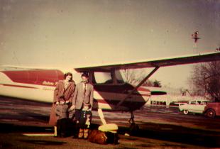
As luck would have it, the weather was perfect on Monday, February 2, 1959 when I hustled my wife Margaret and our children Jimmy, four, and Andrea, two, to the airport before the weatherman could change our minds. With 110 hours under my belt, I felt ready for the big trip.
A flight plan was filed from Salem, Oregon to Red Bluff, California with a stop in Albany to replenish our supplies. We were in great anticipation of having the trip of our lives and wanted to make it as carefree as possible. We carried clothes for our family, two hundred dollars and two gasoline credit cards. In addition, the club had given us a complete outfit of survival gear.
The club airplane was a Cessna 170 converted to tricycle gear
(171) and well instrumented including a low frequency receiver and VHF
transmitter. At 11:35 a.m. we took off and headed south. The trim tab
was set for a long climb at 100 miles per hour to altitude 9500 feet.
Below us passed the beautiful Willamette Valley, framed by the Cascade
Mountains and the Coast Range . We flew over Eugene and Medford, then
crossed the high Siskiou Mountains. Mt. Shasta was east of our course
and stood there with all its majestic beauty. I kept close check of all
landmarks and gave position reports by radio to the ground stations. Trouble
in these mountains would indeed have serious consequences, but our Cessna
171 behaved marvelously. Right on time we crossed Shasta Lake and approached
Redding. Gradually we descended, and two hours and 35 minutes after having
left Albany, we landed in sunny Red Bluff.
The first stop was to take the kids to the bathroom; then we could attend to other important things, such as refueling, eating and planning the next leg of our trip.
One hour later I heaved the kids aboard, helped my wife into the airplane, got in myself and started the engine. With ease we took off and headed for San Francisco . At times it was a little problem with the children for whom it was not easy to sit still so long. Sometimes they had a fight, sometimes they played with the airplane fixture so that we worried about them tearing the club plane apart. Much of the time they were asleep, and Margret and I could enjoy the trip. When they woke up, of course, we had to have some cookies or fruit ready to keep them happy.
We landed at Buchanan field near Concord , 15 miles northeast of Berkeley. The airport operator, Mr. Bradley, received us very kindly and even drove us to a motel, where we stayed for the night.
Tuesday morning we took the bus to Berkeley and visited friends at the University of California. It was nice and warm, and the clothes we were used to in Oregon made us feel uncomfortable. My business concluded at the University, we went back to the airport. By 3:30 p.m. we were ready for take—off. I piloted the plane over Oakland and San Francisco , thence to Salinas and on south. By the time we reached Passo Robles the sun was setting, and we decided to spend the night there. The airport was over six miles from the city, and consequently the taxi fare was rather high.
The weather was still very good on our third day, and we continued the trip to Los Angeles . Orientation on this leg was easy; we flew around Mt. Pinos, 8831 feet, to Grapevine and then followed Highway 99 to Los Angeles. Over the city, smog reduced visibility considerably, and I had to descend. Our destination was the small airport of El Monte L.A. I easily spotted the field but noticed that traffic was heavy. Furthermore, after one unsuccessful attempt to land, I saw that the runway was short and had a right—handed pattern. I made another approach, but again overshot the field. On my third try, I landed in the middle of the runway. With the foot breaks I stopped the plane just ahead of a row of tires. Happy that I made it, I taxied to the parking place. The attendant helped us tie the airplane down and filled the tanks with gasoline. Casually he remarked: “Next time don’t land on that strip, it has been X-d off’”. Well...
We enjoyed 24 wonderful hours in Pasadena and Los Angeles . Our friend Steve even loaned us his car, and we could drive to Marineland where we enjoyed watching the underwater feeding of the fish and the amusing feats of the trained whales. Driving on the freeways, however, came close to a nightmare after the peace we had enjoyed in the air. We also drove through beautiful orange groves and would have liked to buy bushels of the beautiful fruit, but we had to watch the load of the airplane.
After a full day’s visit we took off from El Monte airport. Right after take-off we ran into heavy smog. We followed a freeway in an easterly direction. But something seemed wrong. Big mountains were dead ahead of us, barely visible through the smog. I decided to climb and fly over the smog layer. After about five minutes, we spotted a large airfield near a city which I identified as San Bernadino. This meant that I had to turn 30 degrees to the southwest. After flying in that direction for a few minutes, we suddenly came out of the smog. Below us laid the towns of Redlands and Beaumont .
Navigation now was easy, however there were several airplanes flying this route. I had to watch the altimeter and fly ad odd thousand plus 500 feet since the direction was between 0 and 180 degrees. Five thousand five hundred feet was adequate in our case. At one point we passed another light plane which was slower than ours. Following air traffic rules I overtook him at a safe distance to the right. Meanwhile we had flown over Palm Springs and entered the Coachella Valley. I descended 2000 feet to have a closer look at the date palm plantings in this area. We also saw several beautifully landscaped properties and resorts.
Two hours after take-off we arrived at our destination, El Centro and landed 9 feet below sea level in the Imperial Valley . I taxied around the many parked airplanes and tied down our 171. We unloaded our luggage and went to the airline terminal. The last limousine had left several minutes ago, so we decided to hitch a ride into town. Most motels were filled, but we found room in a large hotel. Winter being tourist season, the rates were rather high.
Next day the farm advisor took me on one of his daily trips. I was amazed to see the intensity of agriculture in the Imperial Valley . At a time when the north was shivering in the cold, we saw farmers harvesting tomatoes, squash, lettuce and carrots.
Towards four o’clock we flew on to Yuma, Arizona . Here, next to the Mexican border, we had another friend (Vince) with whom we stayed for the night. Next morning we took a short trip through the countryside to see large fields of lettuce and alfalfa, as well as grapefruit and tangerine groves and an occasional roadrunner bird.
At 10 a.m. that Saturday my family and I again boarded the airplane and headed for Phoenix. The weather was still perfect. We flew over the Colorado River near Laguna Dam and entered the desert. Wild mountain cliffs alternated with flatter areas. If we should have had to make a forced landing, it would have taken days to walk to inhabited areas. There were no checkpoints of any significance. We should have been near Gila Bend, but nowhere did we see a town. I decided to call Gila Bend by radio. According to the time en route and course heading I gave, the controller placed me near Casa Grande, Arizona . -I later discovered that I was still on Pacific Standard Time instead of Mountain Standard Time.- As our flight progressed I noticed a railroad, an airfield and a road. I informed the radioman of this and expected him to tell me to change course at any time. Then I saw a lot of houses and reported this. The answer over the radio was: “If it’s a large town, it’s got to be Phoenix”. Well, I was on course all the time!
Sky Harbor in Phoenix is a large and very busy airport. At this stage of our trip I had become used to radio communication, and by following their instructions had no trouble setting the airplane down and parking it at the Transient Terminal for private planes. In Phoenix we were guests of the Crowley ’s, former Oregonians. Our and their children had a great time, and we could visit and go sight—seeing. Just outside Phoenix we saw large and beautiful fields of cut flowers right besides the desert and bizarre native cactus plants.
Next morning the weather was changed. It was cloudy and windy, and during the night it had even rained. Under the circumstances I decided it best to postpone our departure for one day. Frankly, the return trip was worrying me.
Monday morning I called the weather bureau. The report was not too encouraging, but I decided to drive to the airport and get the weather picture in person. The wind in Phoenix was 15 knots with gusts up to 21 knots. Surface winds on my intended route were even higher: 20 to 25 knots, and the upper winds were 40 to 60 knots from 270 degrees. Visibility was reported good. The 24 hour forecast predicted another storm. It was either fly the same day or stay in Phoenix several more days. After considering all these details, I decided to fly immediately.
We followed highway US 66 westbound. Everything went well, and after three hours we arrived at Barstow, California, our refueling stop. No attendant was in sight. I walked to a neighboring house, and a small boy informed me that this was a self service station. I returned to the airplane, and while filling the wing tanks, Margret had to hold the wing strut. We did not want to risk the 20 to 25 knot wind to tip our ship. The engine needed one quart of oil, but I could not find the kind we usually used. I put the gasoline hose back where it was, wrote myself a sales slip and put $ 10.50 into the box. Margret was anxious to get out of the cold wind into the cozy cabin. While she held the controls back to avoid the wind from lifting the tail, I put the children into the back seat and climbed in myself. We wasted no time taking off again.
The strip was short and rough, but somehow I missed the TV antennas and powerlines. I filed a flight plan to Bakersfield through the radio. It was now 5 p.m. and the setting sun blinded us. We failed to see our first checkpoint and decided to fly towards the radio beam and at a compass heading of approximately 240 degrees.
We flew and flew. No familiar checkpoint showed up and the sun was long gone. Below us was nothing but desert and in the distance tall mountains. Margaret began to dislike this night flying and wanted to get down. Slowly it dawned on me that I was not an instrument pilot and perhaps we should better land. But where? I could get no assistance through the radio, although I tried all channels including emergency. It was dark in the cabin, and I could no longer read he map. I kept the same course and after a while was relieved to see the lights of a small community. A few miles past it we saw a rotating beacon and approached it. As we came closer, we found a well lighted runway and tetrahegon. Without hesitating I entered the traffic pattern and made a perfect approach. The power was a little higher than usual, but even so we ballooned slightly in the strong wind before settling down. Taxiing in this heavy wind — we later learned it was 30 knots— was a major problem. A little relaxation at the controls would have resulted in the wind tipping our plane over and causing considerable damage.
As we approached the hangars we were stopped by a red light. A follow—me jeep drove up and directed us to a place to park the airplane. After I cut the engine, military personnel approached us and asked us why we had landed on a restricted field. We had landed on a military field where top secret work was carried out. The strong wind had driven us considerably off course. We tied the airplane down securely and went to the Officer of the Day. I expected a severe reprimand. He indicated that had we flown a few miles farther and landed on a civilian field we would have saved a lot of trouble. But he was extremely courteous and understanding with our situation, and said he’d rather see us here than search for us in the mountains. I had to write a report and explain our emergency. We were permitted to stay at a local motel, but had to promise to fly the airplane off the base before 8 a.m. the next morning. The following morning we appeared on time and took off with no complications. I first planned to land on a civilian field close by, but once in the air, I decided to fly south and then toward Bakersfield. The weatherman predicted a new storm for the Sierra Nevadas in 24 hours. The mountain were clouded in, but when we came to the turn—off point for the Tehachapi pass and saw an opening, I flew on and easily reached Bakersfield in the flatland.
We were in excellent spirits, all had gone so well: We outsmarted the weather, crossed the Sierra Nevadas and were in safer territory again. Our next intended stop was Sacramento . After a leisurely meal we went into the pilots’ lounge. On a large table I spread out my aviation charts and planned the trip. I had learned of what great importance careful planning is. Nothing exciting happens when everything is planned, but little and big things occur when tiny details are overlooked or not impounded strongly into the pilots mind. All there is to do when flying is to follow through with the plan. At times this may be made difficult by such distractions as sun in the eyes or radio communications.
The Bakersfield weather bureau reported rather low ceilings in the San Juan Valley cities, but visibility and winds were favorable. I decided to fly at 2500 feet. We encountered scattered clouds and often had to fly under, over or around them. We flew through several rain squalls where Margaret and the kids got a kick out of watching the rain hit the windows and watching me evade clouds. I kept close track of the larger airports we were flying over, in case we had to turn back. Just north of the Fresno airport a solid wall of black clouds was in front of us. This was too much. At once I contacted the Fresno tower, cancelled the flight plan and obtained permission to land.
Our first stop was the weather bureau to ask when it was going to clear up. The answer was: “Tomorrow”. We did not mind spending the afternoon and night in Fresno. I remembered a college friend in town, and he generously drove us to a hotel where we rented two clean, moderately priced rooms.
Next morning we hired a taxi to the airport. The sky was still clouded, but we were predicted a ceiling between 2000 and 4500 feet along the way. Again we danced around clouds but easily reached Sacramento. In the early afternoon I visited friends at the California Department of Agriculture. Then we flew the short hop to the University airport at Davis, where we were met by another friend and stayed until the next day.
On our final leg we would have liked to fly along the coast. But on my call to the Sacramento weather bureau, I was informed that the coast was fogged in and the way via Red Bluff and the Siskious would be more advisable. I did not dare to question the meteorologist and changed my plans.
At 10 a.m. February 12, 1959, we left Davis northbound. There was no problem in following highway US 99, dodging a few clouds and landing in Red Bluff. Here we refueled, had lunch, checked weather, and filed a flight plan for Salem, Oregon.
Flying at 10500 feet we crossed the Siskiou mountains and enjoyed spectacular scenery. Considerable snow had fallen since we flew the same route 10 days ago. It was a long flight, and we had a little headwind. The children were getting restless, and I had to land in Eugene, which we reached three hours and 20 minutes after take-off. The short flight from Eugene to Salem was very pleasant. I tuned in to a broadcasting station, and with music and song we reached Salem, Oregon.
One day after our return rain, snow and fog closed the mountains solid again. You may call it a series of luck, occasionally combined with good judgement. Anyway, we had a wonderful and unforgettable vacation trip.